Pleistocene
Fossil Beds at the east side of Cheviot Hills
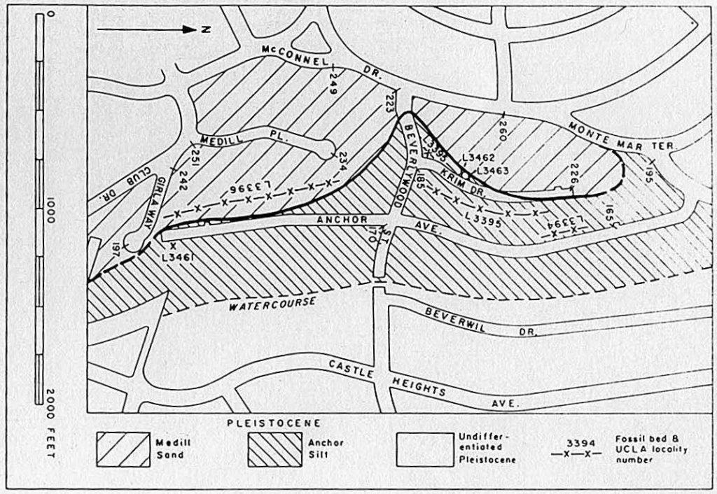
In 1954/1955, Peter U. Rodda of the UCLA Geology Department noticed fossil deposits in the excavations for the last housing tracts in the Cheviot Hills area. He described and labeled two Pleistocene epoch formations – naming them after the area’s new streets: “Anchor Silt” (for Anchor Avenue) and “Medill Sand” (for Medill Place). In February 1956, soon after Rodda’s work was completed, Medill Place north of Beverlywood Street was renamed Krim Drive.
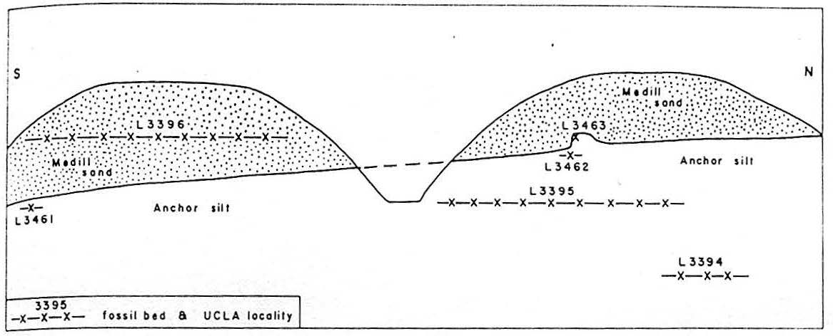
Recent excavations made in the Cheviot Hills, Los Angeles County, California, have exposed fossiliferous marine Pleistocene strata. Two new formations occur in this area. The lower Pleistocene Anchor silt consists of 6o feet of soft buff silts, and is unconformably overlain by the upper Pleistocene Medill sand, consisting of 6o feet of grayish, loosely consolidated sand and gravel.
Peter U. Rodda, “Paleontology and Stratigraphy of Some Marine Pleistocene Deposits in Northwest Los Angeles Basin, California,” Bulletin of the American Association of Petroleum Geologists (Nov. 1957), abstract.
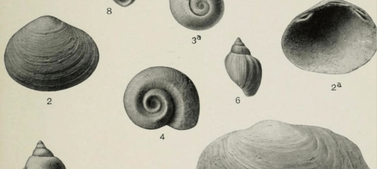
Eighty-three species of fossils, mostly mollusks, are identified from five localities in the Anchor silt, and 21 species of mollusks are identified from a single locality in the Medill sand. The fauna of the Anchor silt probably lived offshore at a depth of 25-35 fathoms on a silty or muddy bottom, and in water considerably colder than that present today at this latitude and depth. The fauna of the Medill sand represents a warm bay habitat.
The Anchor silt is faunally and lithologically similar to parts of the San Pedro and Timms Point formations at San Pedro, to small exposures of lower Pleistocene in the Pacific Palisades area, and to unnamed lower Pleistocene units in the Baldwin Hills.
Anchor Silt
The older of the two formations, Anchor silt is named from exposures along Anchor Avenue. Its maximum thickness is 6o feet, and consists largely of massive, buff-colored, fine sands and silts with thin, irregular beds of cobble gravel. It is well developed north of Beverlywood Street in the cuts between Anchor Avenue and Krim Drive and at the northwest corner of Beverlywood Street and Krim Drive. Fossils (mostly mollusks) indicate the area was submerged in about 150-200 feet of water cooler than 50 degrees Fahrenheit during the lower Pleistocene age.
The Anchor silt appears to have been uplifted and eroded prior to deposition of the Medill sand. The position of the Castle Heights area along the Newport-Inglewood uplift easily accounts for the vertical movement and possibly accounts also for some of the contorted bedding locally present in the Anchor silt. Then again, it might also be attributed to “submarine slumping.”
Medill Sand
This newer formation, from 126,000 and 11,700 years ago, was named from exposures along, and adjacent to, Medill Place, is a mixture of fine to coarse sand and gravel. It has a maximum thickness of nearly 60 feet and was well exposed north and south of Beverlywood Street. The irregular pockets of gravel consist of well-rounded metamorphic and granitic cobbles and boulders up to 15 inches in diameter. White siliceous shale fragments, so common in the gravelly sections of the Anchor silt, are not present in the Medill gravels. These Medill gravels have a fine to coarse, gray-brown, sandy matrix, and have a maximum thickness of about 10 feet, though the thickness and lateral extent vary greatly from place to place. The single fossil bed in the Medill sand is in coarse grayish sand at an elevation of about 220 feet, and is exposed along the east-facing cuts for a distance of 500 feet, from Girla Way north toward Beverlywood Street.
The fauna of the Medill sand is much smaller, and is somewhat better preserved than that of the Anchor silt. This upper Pleistocene epoch fauna has a warm-water aspect. It most probably represents bay habitat, suggesting conditions similar to those existing in the Newport Lagoon, Orange County, California, though probably warmer.
Click HERE to download the full PDF version of Peter Rodda’s manuscript, “Paleontology and Stratigraphy of Some Marine Pleistocene Deposits in Northwest Los Angeles Basin, California,” published in the November 1957 Bulletin of the American Association of Petroleum Geologists.