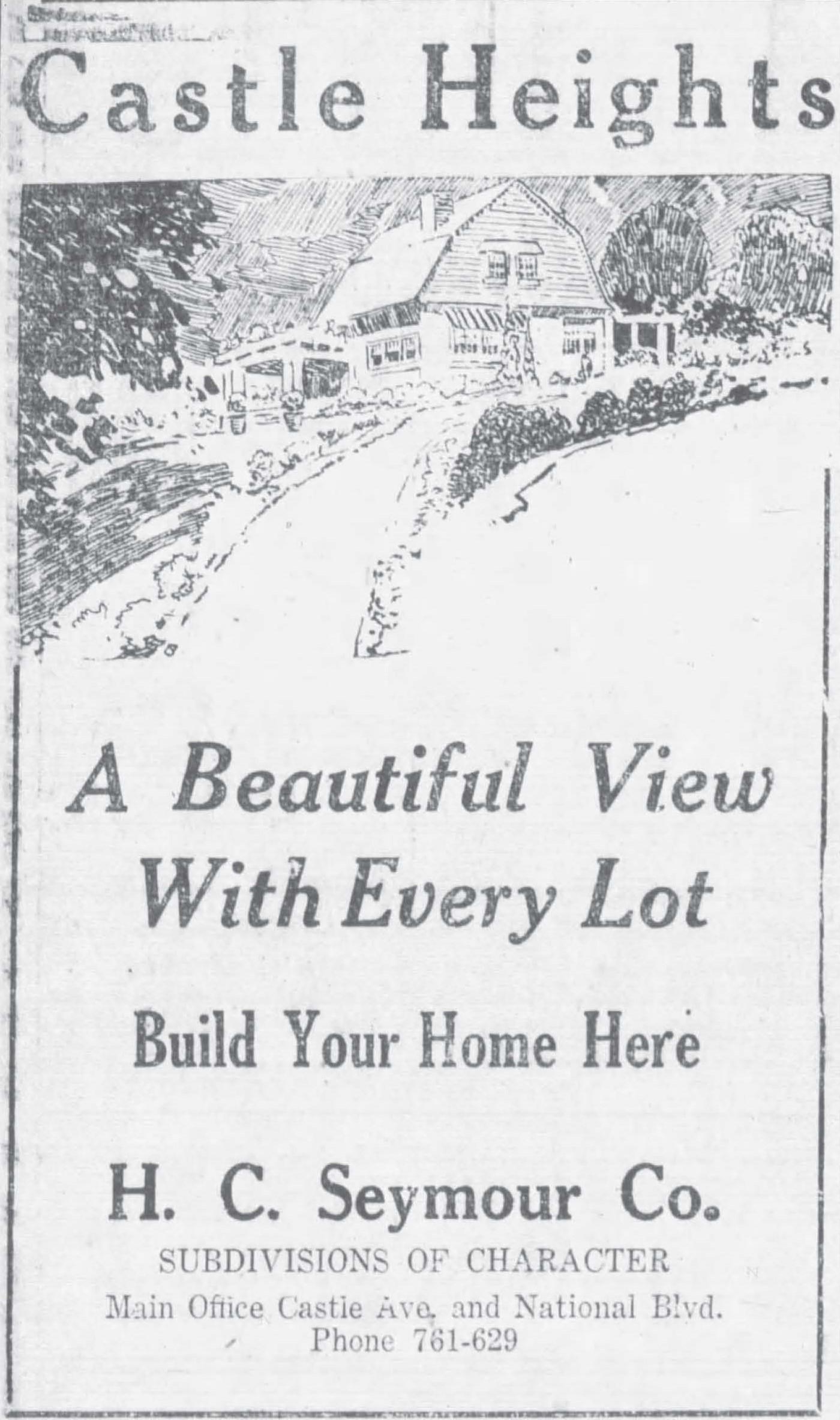
Castle Heights
Starting in 1922, the H. C. Seymour Company offered home-sites in Castle Heights, immediately east of the California Country Club. Castle Heights combined part of the Palm City Tract and Tract 721 (both outlined below). Most of the latter was resubdivided as Tract 7195, with the City Council’s approval (subject to a storm drain installation), on May 5, 1924. The original Castle Heights development has been called (with varying degrees of accuracy) Palm City (or Palms City), Culver City, Los Angeles, Cheviot Hills, Monte-Mar Vista, and Shelby Heights.
The current “Castle Heights” designation includes communities further east and down the hill from Seymour’s Castle Heights, areas formerly known as “Arnaz” and “Ivywild.” None of it is within the Cheviot Hills Home Owners’ Association, the Beverlywood Homes Association, or the California Country Club Homes Association. Area signs were erected by the Castle Heights Neighborhood Association, “a volunteer non-legal entity comprised of and organized for the residents of Castle Heights,” which is apparently inactive.
Castle Heights-area subdividers
Palm City Tract
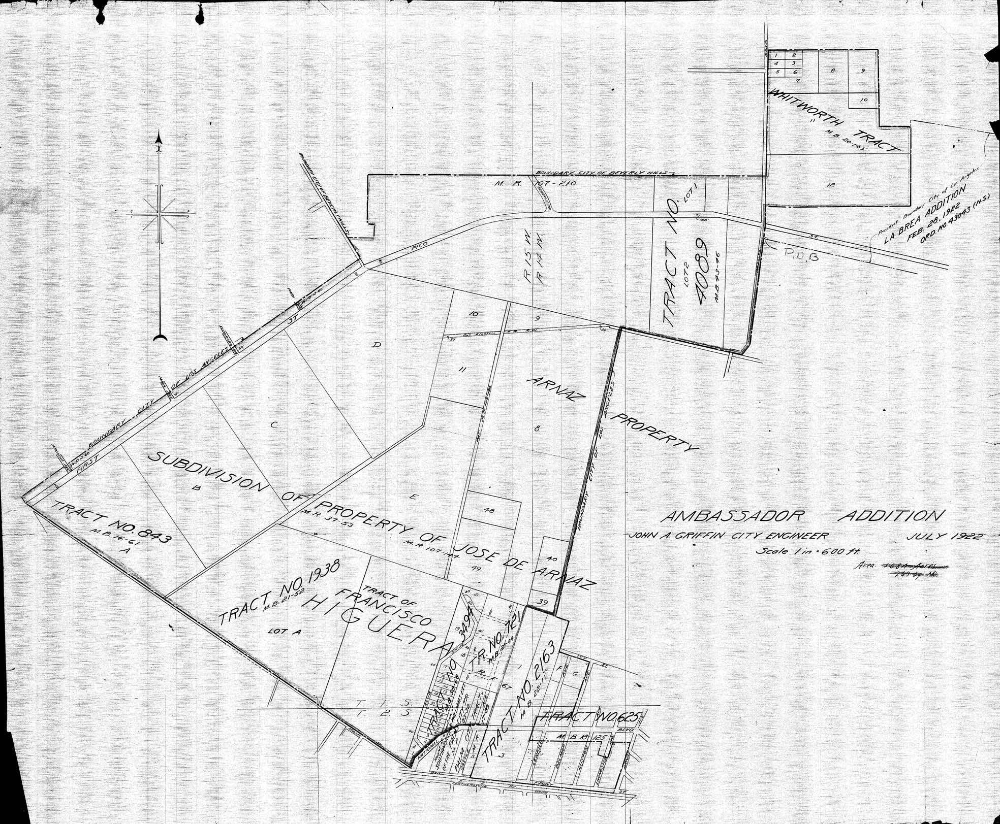
With the partition of Rancho Rincón de los Bueyes in 1880, Francisco Higuera divided his (nearly) half of the rancho into four, several hundred acre “Lots” which would be repeatedly resubdivided, including into Castle Heights. Some subdivisions took their names from The Palms subdivision to the south, itself carved from Rancho Ballona in 1886.
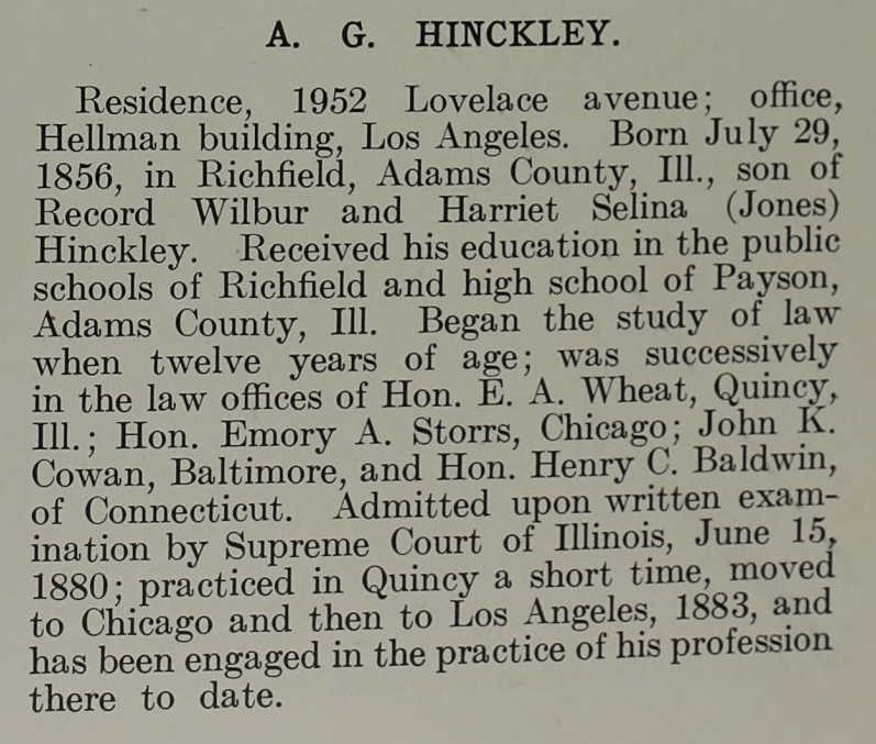
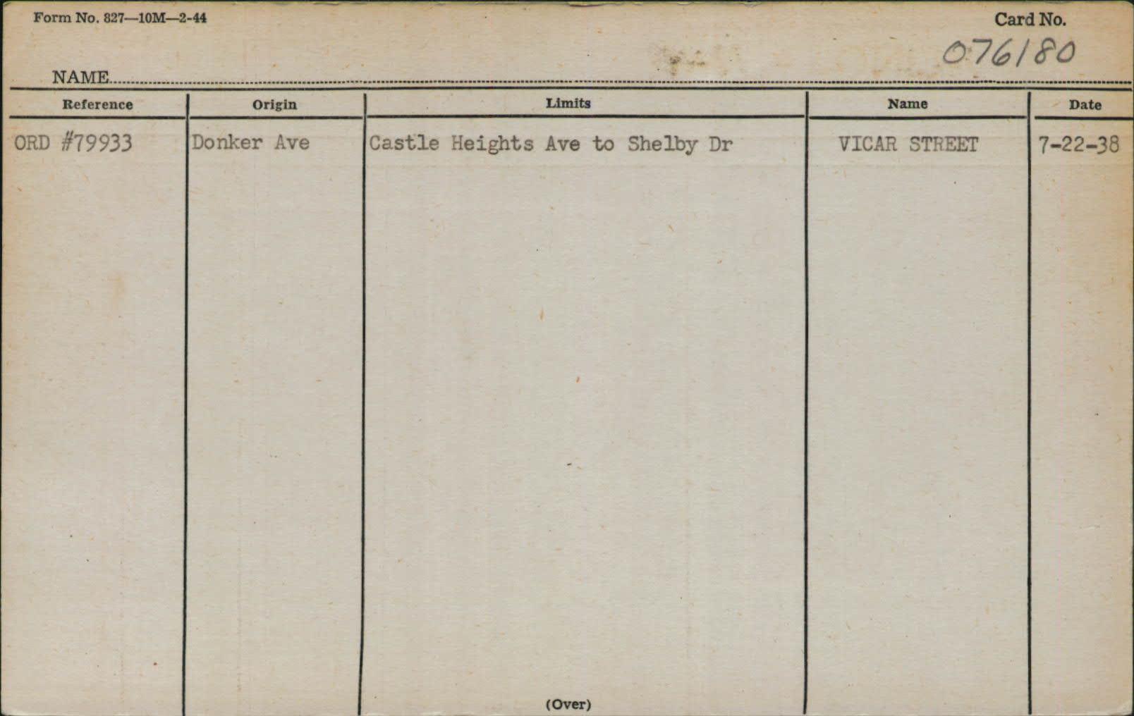
One of the first subdivisions to take its name from The Palms was the Palm City tract, recorded by Adolphus Gustavus Hinckley (1856-1929) on April 15, 1887. It ran north from Neil Street (in 1916, Neil became Winship St.) immediately north of the Los Angeles & Independence Railroad to today’s Vicar Street (renamed from Donker Ave. in 1938). Castle Avenue ran up the middle of the tract, with Block A to the west and Block B to the east. On June 7th, Hinckley filed an “amendatory map.”
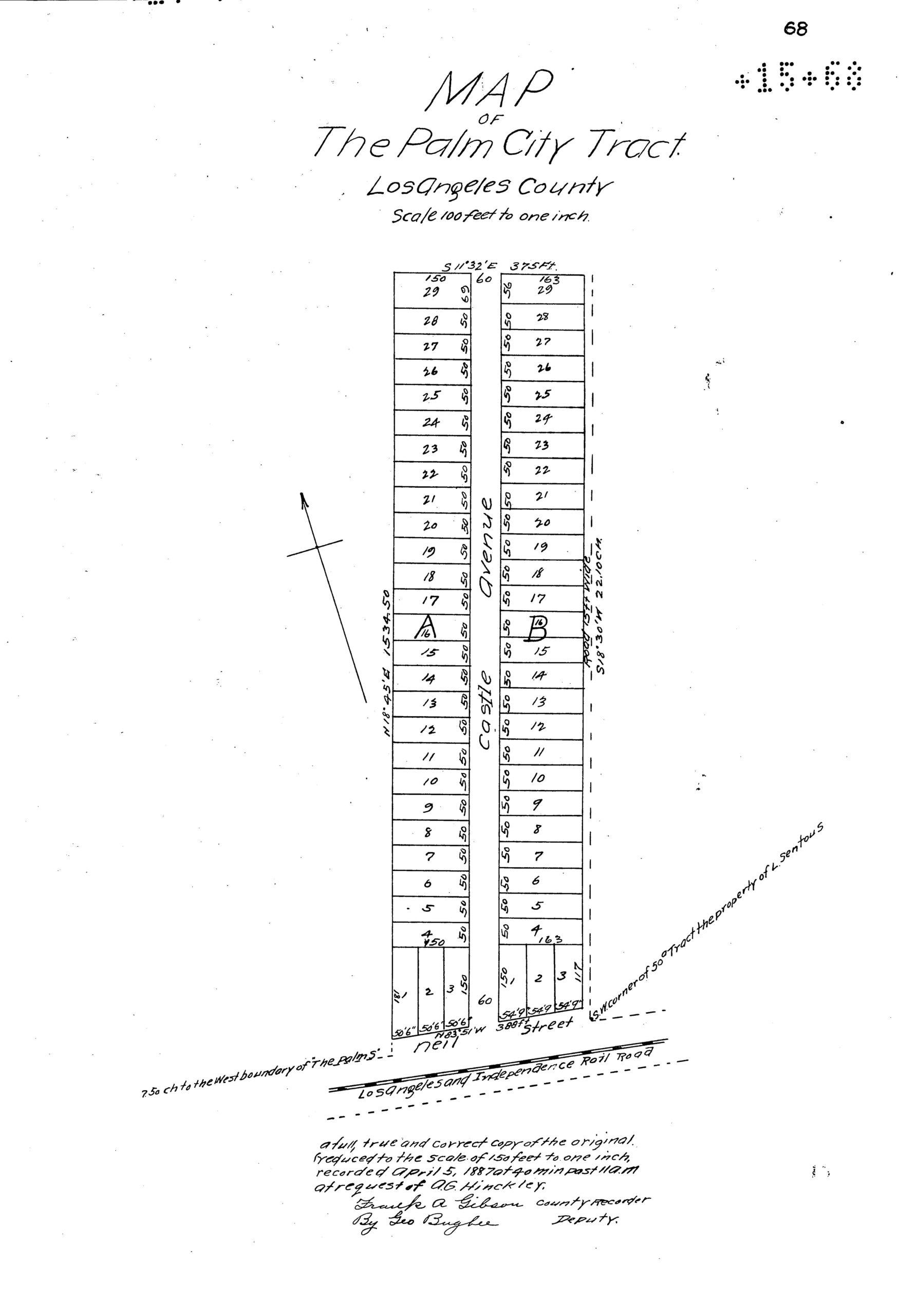
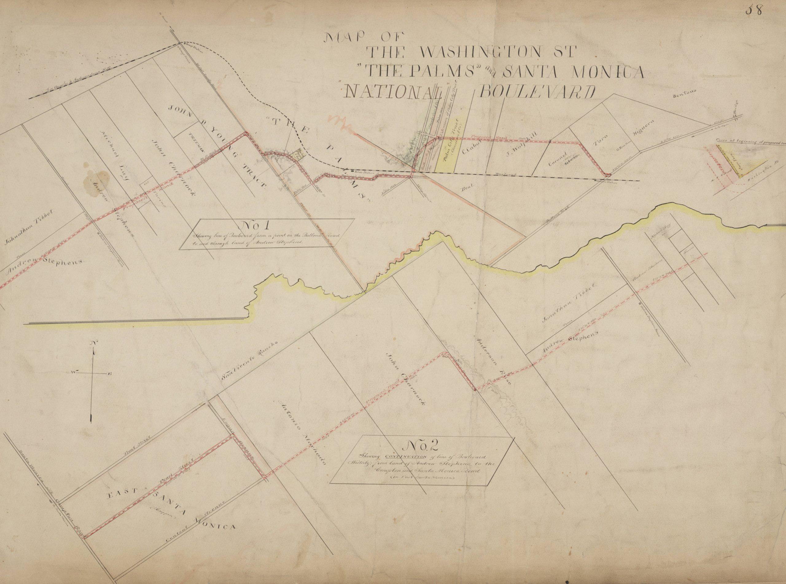
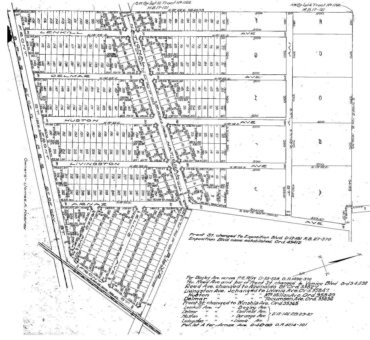
The Palm City tract (in yellow) – along with Southworth & William’s Extension of the Palm City tract, and Weed’s Subdivision of Palm Heights – are shown in the c. 1889 map below. It was drawn to show the path for the future National Boulevard, which would soon cut through those tracts. As detailed on another page on this website, National Boulevard would stitch together old and new roads to connect Los Angeles and Santa Monica via The Palms.

Southworth & William’s Extension of the Palm City tract
Had the term “palming off” not already been in use to mean disposing of something by trickery, it could have been coined based on the misleading advertisements blaring “The Palms! The Palms! The Palms!” At Southworth & Williams’ Extension to Palm City, lots would be auctioned with no reserve, meaning they would sell for the best offer, with no minimum.
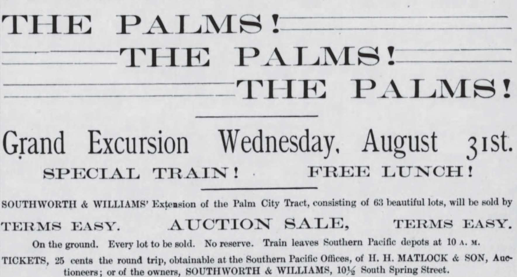
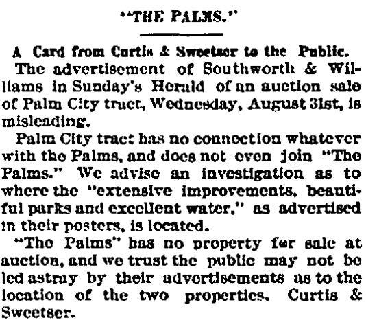
The Palms’ actual promoters emphatically pointed out (albeit three days after Southworth & Williams “The Palms! The Palms! The Palms!” advertisement and on the day of the auction) that the Palm City tract had “no connection whatever with the Palms” and did not even join connect to The Palms.
The Southworth & Williams Extension of the Palm City Tract was apparently a flop. The promised roads, “Palms Avenue” and “William Street” (only the former is labeled on the “Map of the Washington Street, ‘The Palms’ and Santa Monica National Boulevard” above), were “vacated and abandoned and the land therein contained restored to acreage” by the County Board of Supervisors on October 8, 1900.
Weed’s Palm City Heights tract
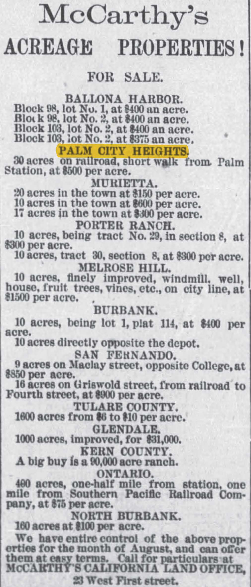
In August 1887, McCarthy’s California Land Office listed “Palm City Heights” among many other “acreage properties” from throughout Southern California, ranging as far away as Ontario and Kern County.
Ivywild (Tracts 625 & 1166)
On October 4, 1911, James A. Keeney (1865-1935) recorded Tract 625, subdividing Tract 1166 (recorded on February 16, 1911). Keeney would market the area as Ivywild, promoting it for the intersection of three rail lines: the Playa Del Rey Line (along today’s Culver Blvd.), the Venice Short Line (along today’s Venice Blvd.), and the Santa Monica Air Line (formerly the Los Angeles & Independence Railroad). (The Playa Del Rey and Venice lines had been added in 1902 and 1903 respectively.) Two years later, Harry Hazel Culver immodestly promoted Culver City for that same confluence of roads: “All Roads Lead to Culver City.”
Tract 721
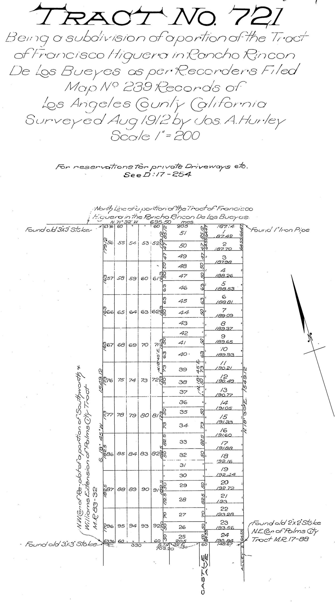
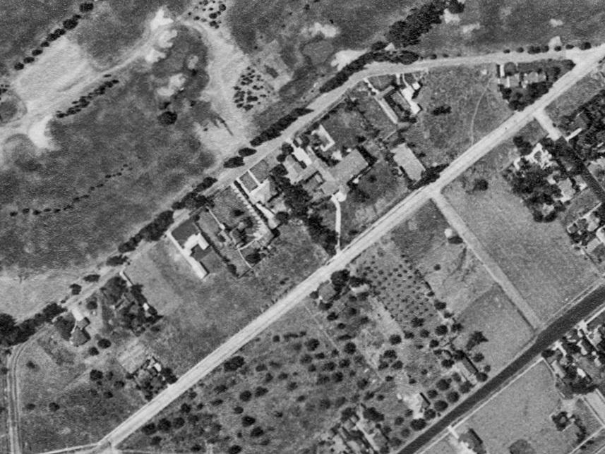
On September 17, 1912, S. C. Graham (likely Samuel Camden Graham (1862–1934)) recorded Tract 721, a 96-lot subdivision of Lot 1 of Francisco Higuera’s 1880 subdivision of Rancho Rincón de los Bueyes. It was north of the Palm City Tract. Graham was a successful oilman and political reformer. Graham’s tract map showed only one street, Castle Avenue.
On February 20, 1913, three women – Marie-Louise Canet (1873-1976), Narcisse Garnier (1880-1968), and Serophine Sentous (1882-1956) – recorded Tract 2163, between the Palm City Tract and Tract 721 (to its west) and Ivywild.
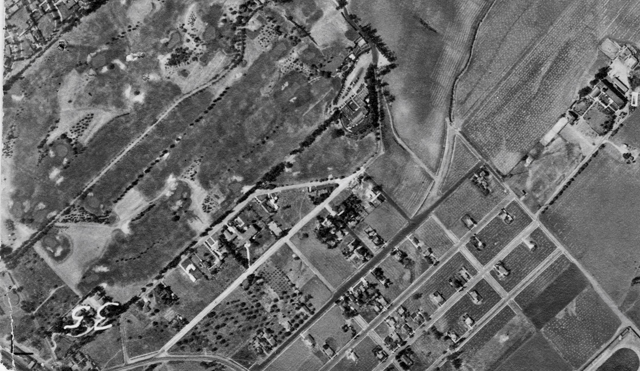
In 1917, what came to be known as the California Country Club was coming to the area. (A page on this website tells its story.) The Los Angeles Times reported:
Culver City Country Club, an organization perfected during the past week, has leased 105 acres of land in the rolling hills just north of Culver City and plans to at once build a clubhouse and lay out a golf course.
The club has obtained a twenty-year lease of the property secured …. Plans for the clubhouse, which will stand upon a high knoll commanding a sweeping vista of the city, the valley and the ocean, are now being drawn by A. S. Heineman.
(L. A. Times, April 29, 1917.)
The club’s land would form the western boundary of Castle Heights, and it became one of its greatest attractions for buyers, such as H. C. Seymour and Harry H. Culver, whose homes would border the club’s golf course.
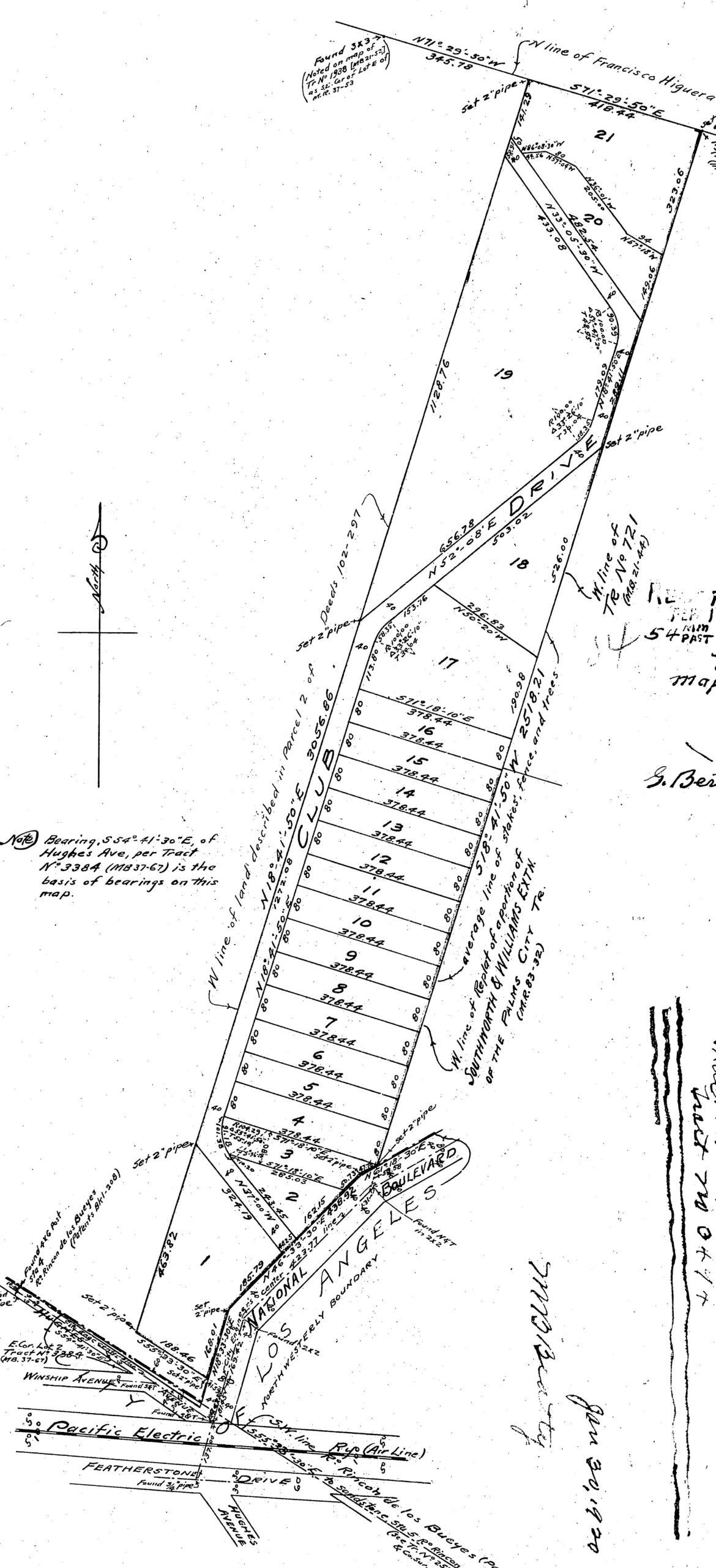
On February 18, 1920, J. W. Calvert recorded the 21-lot Tract 3494 along Club Drive, sitting between the Country Club (to the west) and Graham’s Tract 721 on the northeast and the Southworth & Williams Extension of the Palm City Tract on the southeast. Its southern section covered what had been, in 1887, offered as “Weed’s Palm City Heights.”
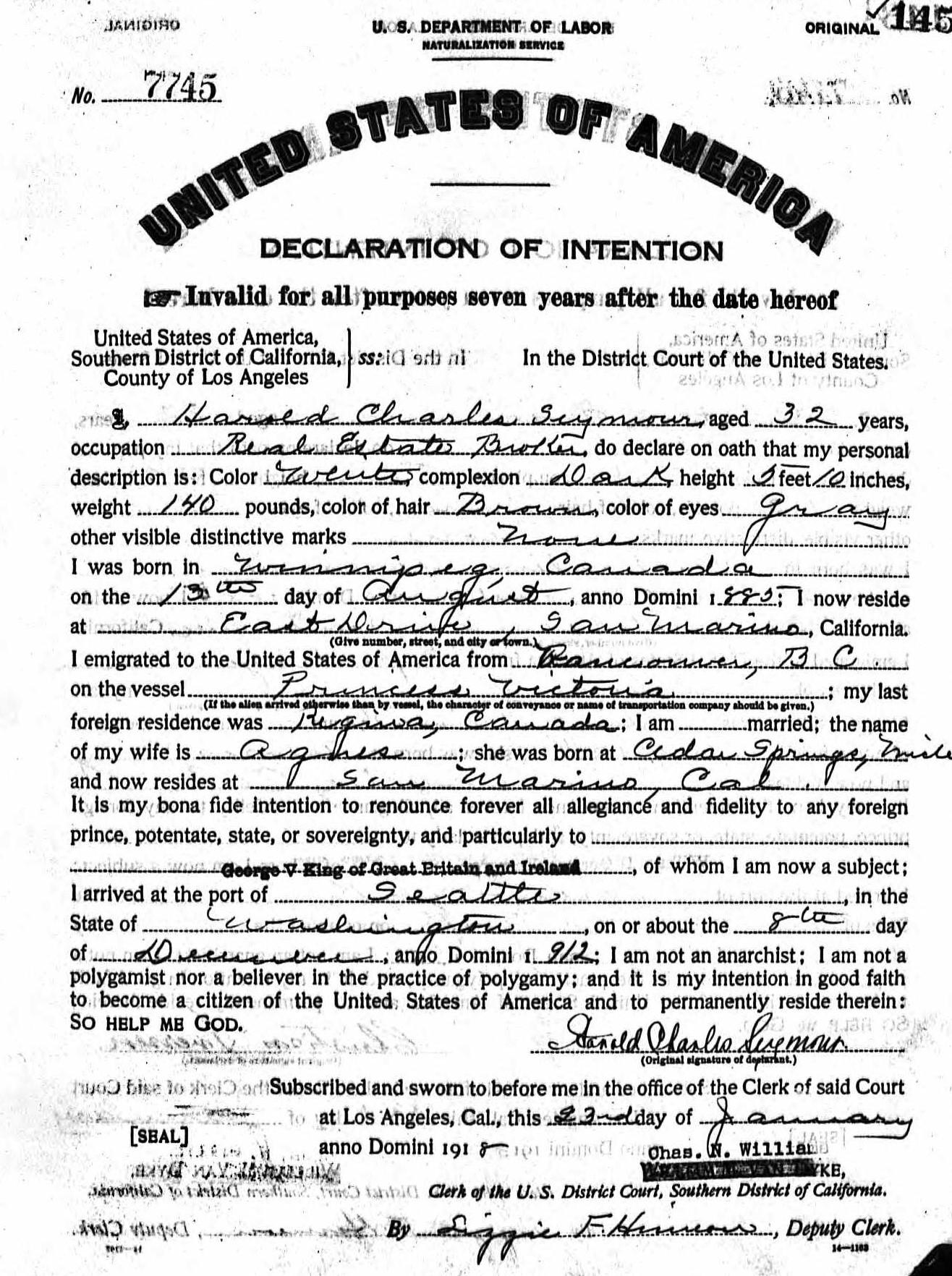
Harold Charles Seymour – “Castle Heights” developer
Because of his role in promoting Castle Heights, where he had his real estate office and where his house remains, some space will be dedicated here to the biography of Harold Charles “H. C.” Seymour. Mr. Seymour was born on August 13, 1885, in Winnipeg, Manitoba, Canada. His father, Maurice, became commissioner of public health in Regina, Saskatchewan and was appointed to the League of Nations in that field. In December 1912, H. C. Seymour emigrated to the United States via Seattle, Washington. He married Agnes H. Spencer (1886-1967) on April 21, 1913, in Santa Ana, California. And he worked as a real estate broker for Harry Culver, going out on his own in that business in 1916. Mr. Seymour became a naturalized citizen in January 1918.
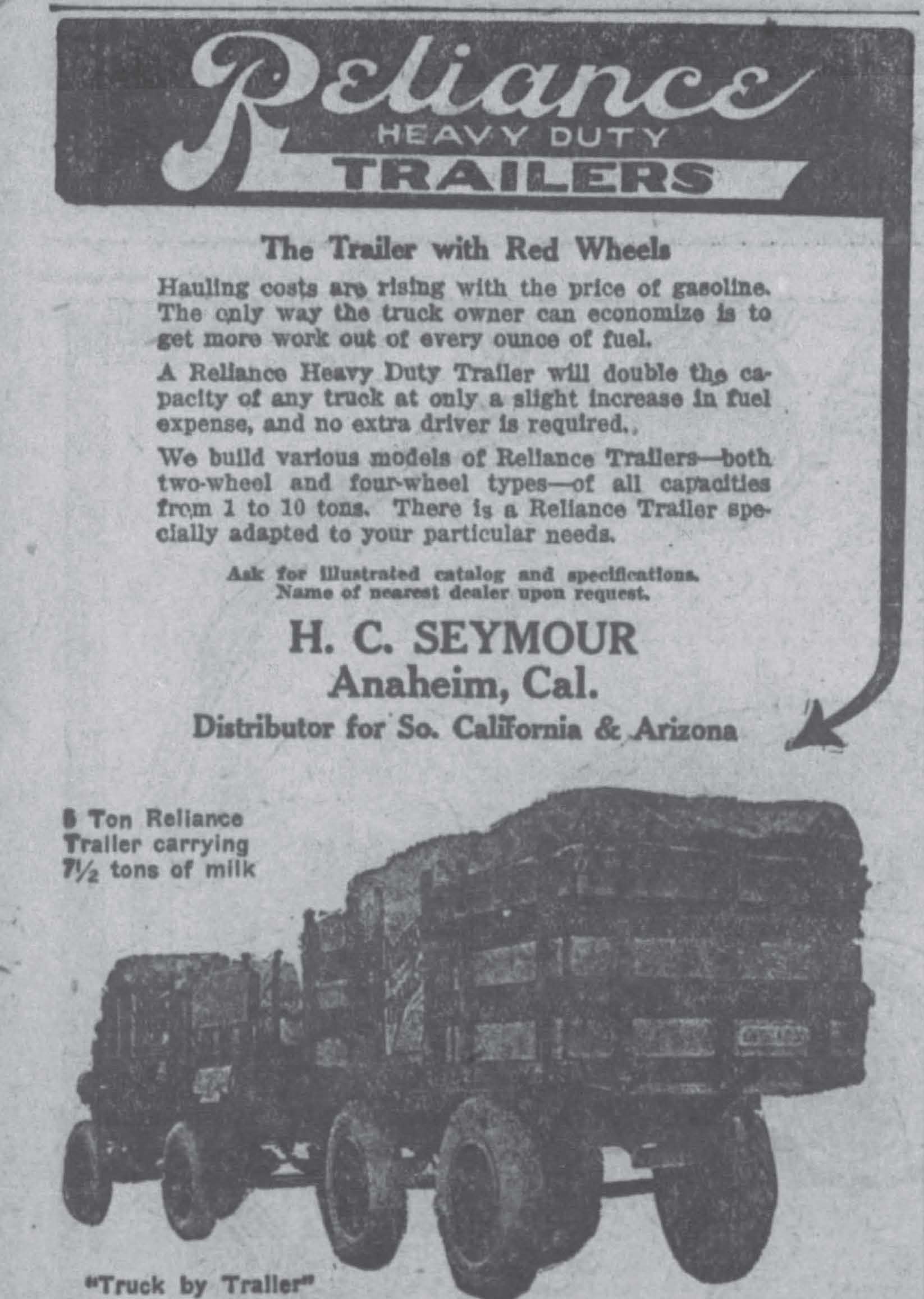
On May 4, 1920, the Santa Ana Register newspaper reported on Seymour’s success in a different business:
Locating at Anaheim just one year ago this month, H. C. Seymour has developed a fine business for the J. I. Case lines he is county distributor for. Fifty tractors, twenty automobiles and 125 trailers tell the story of his success in the twelve months’ period.
His line includes tractors, discs, the Grand Detour plows and the famous Case Touring cars, known as the “all-feature car.” He also is distributor for Southern California and Arizona for the Reliance Trailer line.
[Reliance, which started in 1914, is in still in the trailer business as of this writing.]
In 1923, Seymour developed the Vista Del Mar tract at the northeast corner of Overland Avenue and National Boulevard. In the early 1960s, that neighborhood was demolished to make way for the Santa Monica Freeway.
In 1926, Mr. Seymour was promoting Santa Monica’s Ocean View Beach Club (which was to replace the Dragon bath house) as advertised in the Los Angeles Times. He touted the ability of members to network with what Seymour and his fellows considered desirable people:
“The Ocean View Beach Club will be Ocean Park’s town club and one where one will be able to in time to meet every business man in the district, in a social as well as a business way,” said H. C. Seymour, chairman of the Board of Governors.
Racial and moral restrictions will be carried out rigidly, it has been declared by the board of governors, among whom are: H. C. Seymour, realtor, chairman of the board, Los Angeles, California; Hon. Benj. F. Bledsoe, lawyer, ex-judge U. S. district court; Judge J. Walter Hanby, judge, superior court, Los Angeles; Ed R. Hurst president, California Country Club, Los Angeles; Judge Arthur R. Weber, lawyer, Santa Monica; Capt. A. C. Jewell, executive, Los Angeles county sheriff’s office ….
Venice Evening Vanguard, Aug. 11, 1926 (emphasis added).
Fellow club promoters (listed above) Judge Benjamin Franklin Bledsoe (1874-1938) was a neighbor in Castle Heights and Edward R. Hurst (1880-1943) was a Cheviot Hills realtor and resident. H. C. Seymour died on April 15, 1931, in Los Angeles, California, at the age of 45.
Castle Heights home sales
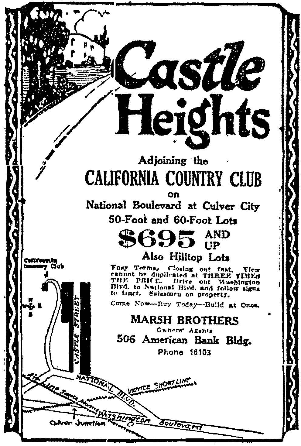
In 1922, “Marsh Brothers” as the “owners’ agents” offered the first lots for sale as “Castle Heights.” The parcels were situated along Castle Avenue and the hills above it, east of the 107-acre California Country Club.
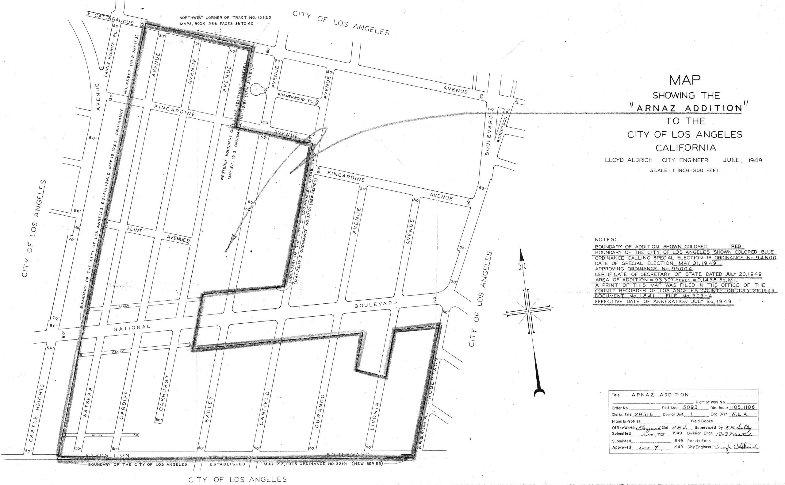
On May 16, 1923, the Castle Heights area was added to the City of Los Angeles as part of the Ambassador Addition. The lots fronting on the east side of (later) Castle Heights Avenue were included, but not the area east of them. Excluded was the “Arnaz” community, a 93-acre island of unincorporated Los Angeles County land named for an earlier landowner, Don José de Arnaz.
By 1923, H. C. Seymour Co. had opened an office selling “Subdivisions of Character.” On September 3, 1923, the company advertised for an experienced stenographer and bookkeeper for a local real estate office, saying to apply in person at H. C. Seymour Co., “Castle Heights, National boulevard and Castle avenue.”
On September 24, 1923, H. C. Seymour Co. advertised Castle Heights in the Venice Evening Vanguard newspaper. That advertisement (shown below) was accompanied by a brief article:
When you buy a lot for a home, it is not the ground you buy. It is the surroundings, the location and the beauty of the particular lot you are interested in. The H. C. Seymour Co. offer you all of these in an abundance in Castle Heights.
Castle Heights is the ideal place for the family; every lot a high one. The air is pure and clear it, the climate ideal, the schools close and the transportation good. Castle avenue, an 80-foot boulevard, connecting Beverly Hills and Hollywood, with Sunset, Hollywood, Santa Monica and Wilshire boulevards, comes through the center of the tract. National boulevard on the front connects with Venice, Arnaz and Washington boulevards.
Venice Evening Vanguard, Sept. 24, 1923.

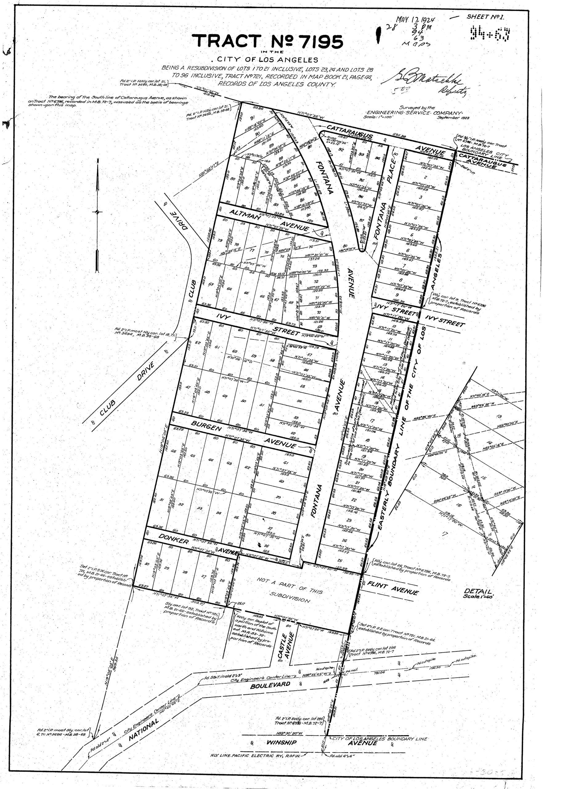
On May 12, 1924, Tract 7195 resubdivided all but a few lots in the southeast corner of Graham’s Tract 721. The Tract 7195 owners were Castle Heights promoter Harold C. Seymour (with his wife Agnes), Tract 721 subdivider S. C. Graham, and their neighbors, including Cornelis and Lottie Donker (after whom Donker Avenue was apparently named; it became Vicar St. in 1938), plus E. T. & Carrie A. Wynn, Philip Gresham, H. M. Elwood, Emil Shostrom, Joseph J. & Kathryn L. Mathe, Lura M. Davidson, Louise E. & Emma Polfer, Ernest A. Bertrand, George M. Gay, J. Ness Porter, Epifana Layana, Margaret M. Titus, W. T. Armstrong, Charles L. Wynn, George Riopel, and Melvin & Vera May Hall.
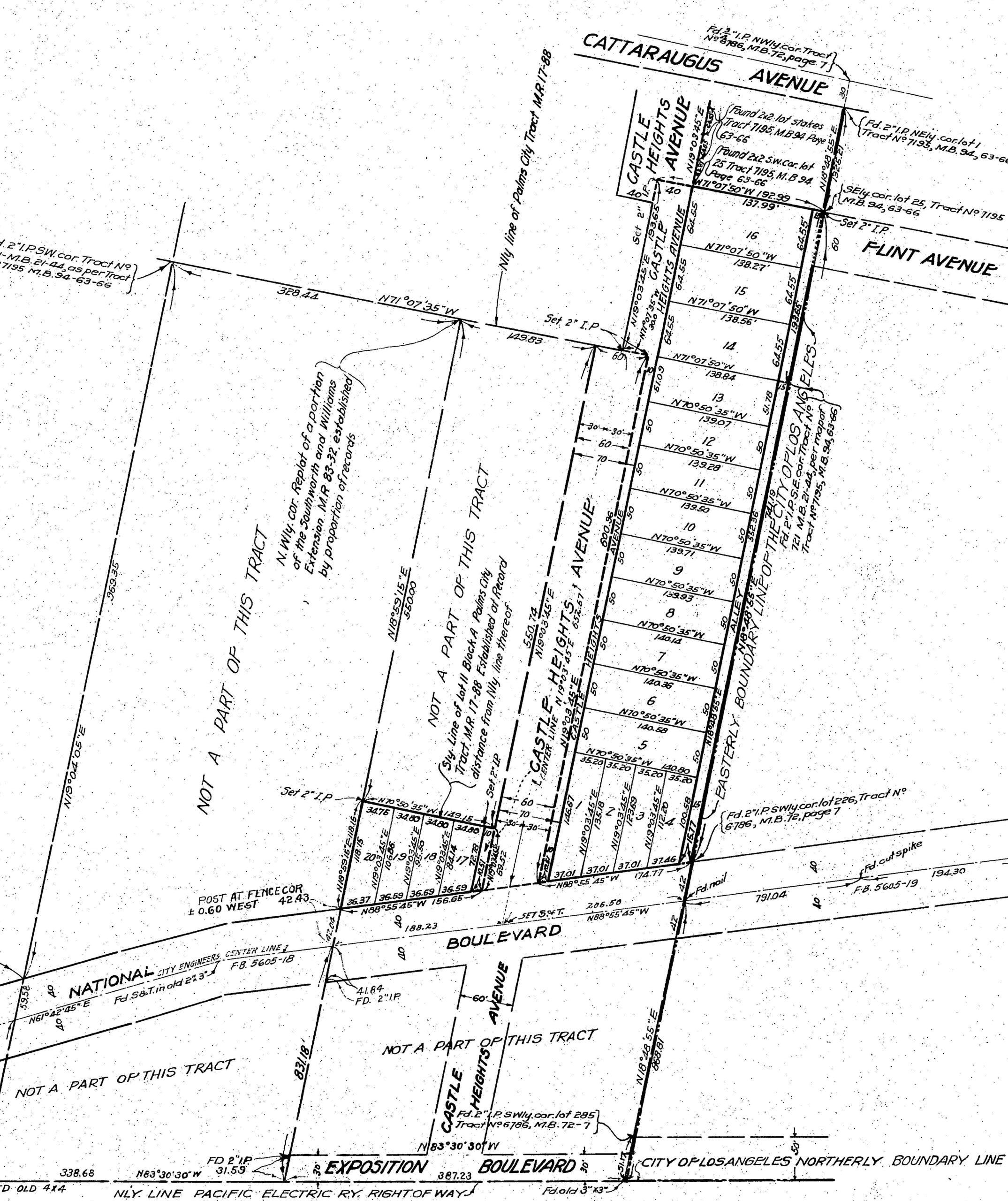
On February 20, 1926, Tract 7196 resubdivided many of the Palm City lots, primarily along the east side of Castle Heights Avenue. Tract 7196 renamed Fontana Avenue, between Vicar Street and National Boulevard, to Castle Heights Avenue. On September 26, 1924, Fontana Avenue had been renamed to Castle Heights Avenue between Vicar Street and Cattaraugus Avenue and from National Boulevard to Exposition Boulevard. Castle Avenue also became Castle Heights Avenue.
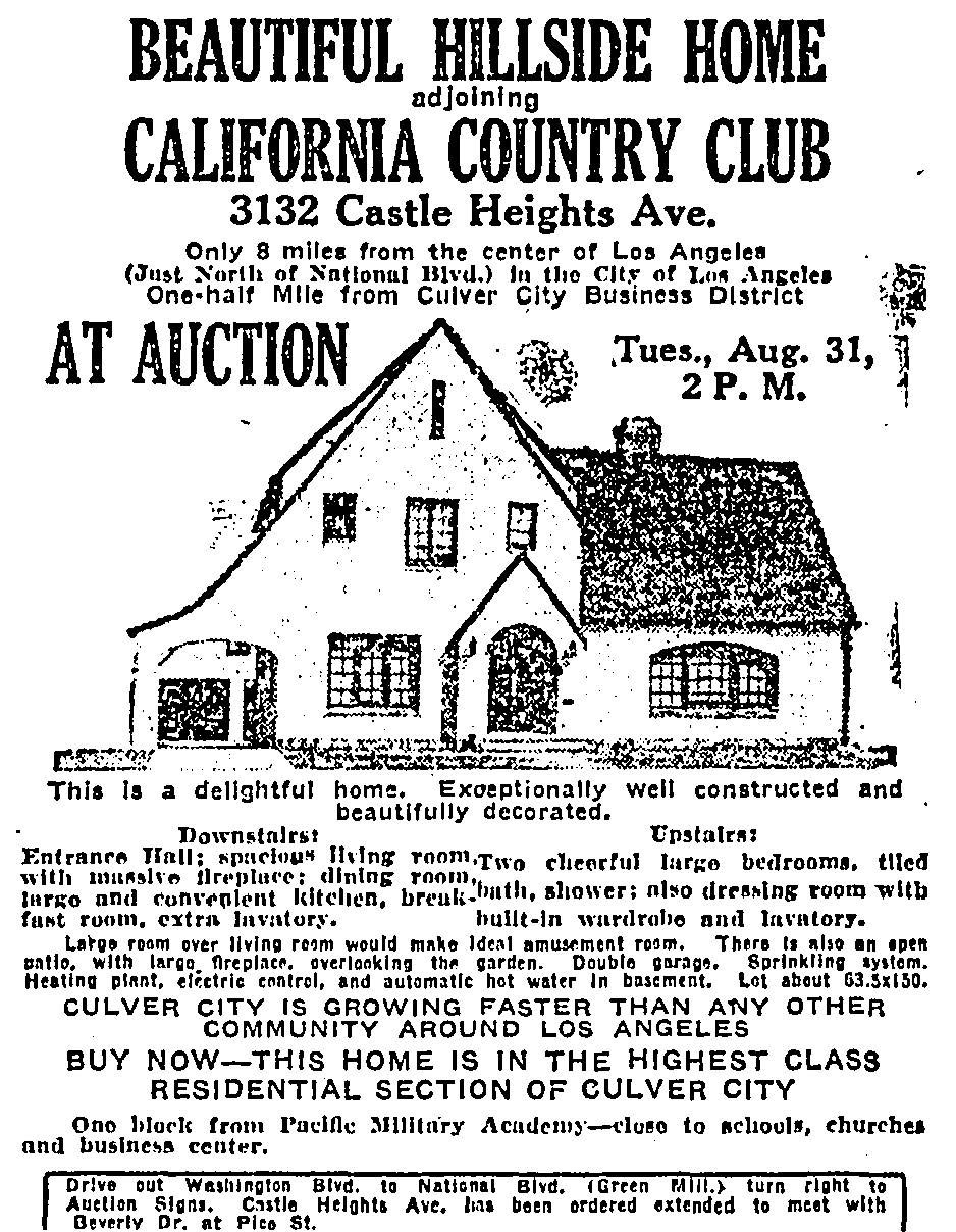
The house at 3132 Castle Heights Avenue was advertised as a “hillside home” “adjoining California Country Club,” and “in the highest class residential section of Culver City.” In truth, the house was not on a hillside and did not adjoin California Country Club. At this writing, the house stands intact, just north of Vicar Street.
On September 2, 1927, Tract 7790 resubdivided lots 4-16 of Calvert’s Tract 3494. The owners and their lenders signed off: Citizens Trust and Savings Bank, Pacific-Southwest Trust & Savings Bank, Clarence M. & Jennie Maude Knox, Judge Benjamin F. & Katharine Bledsoe, Harold C. & Agnes Seymour, George L. & Catherine Smith, Harry H. & Lillian Culver, Josephine R. Spencer, and several others whose names are indecipherable on the document.
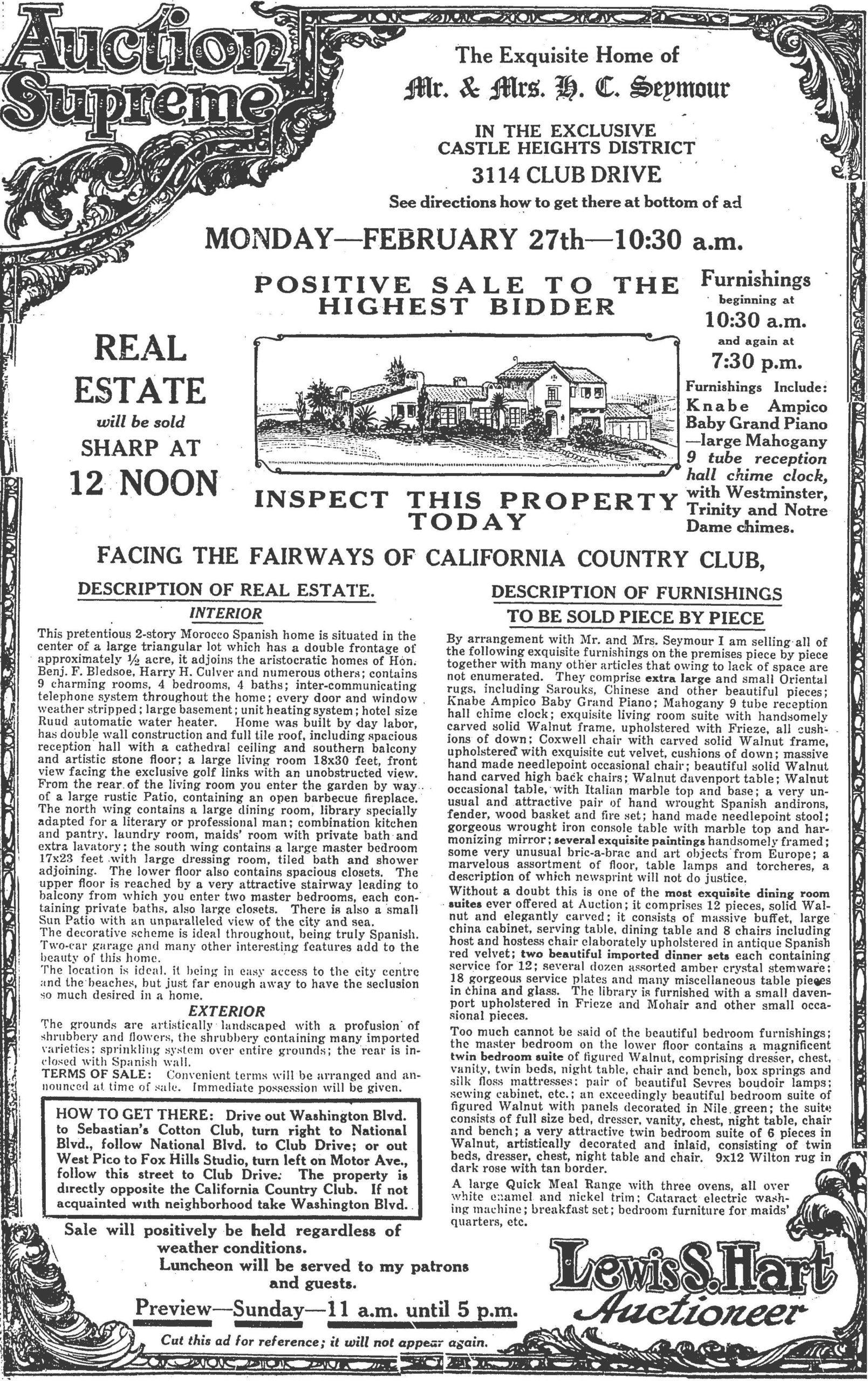
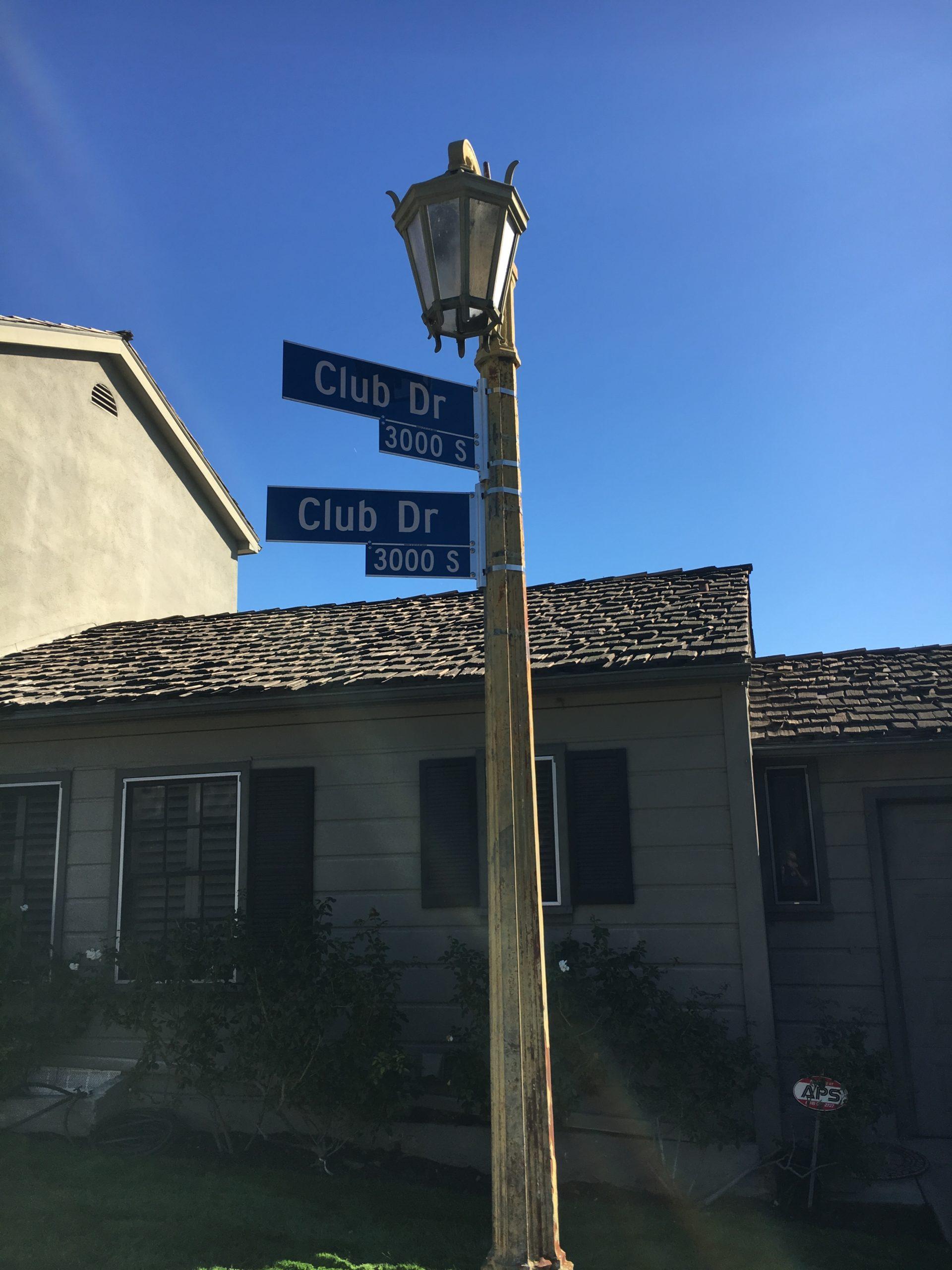
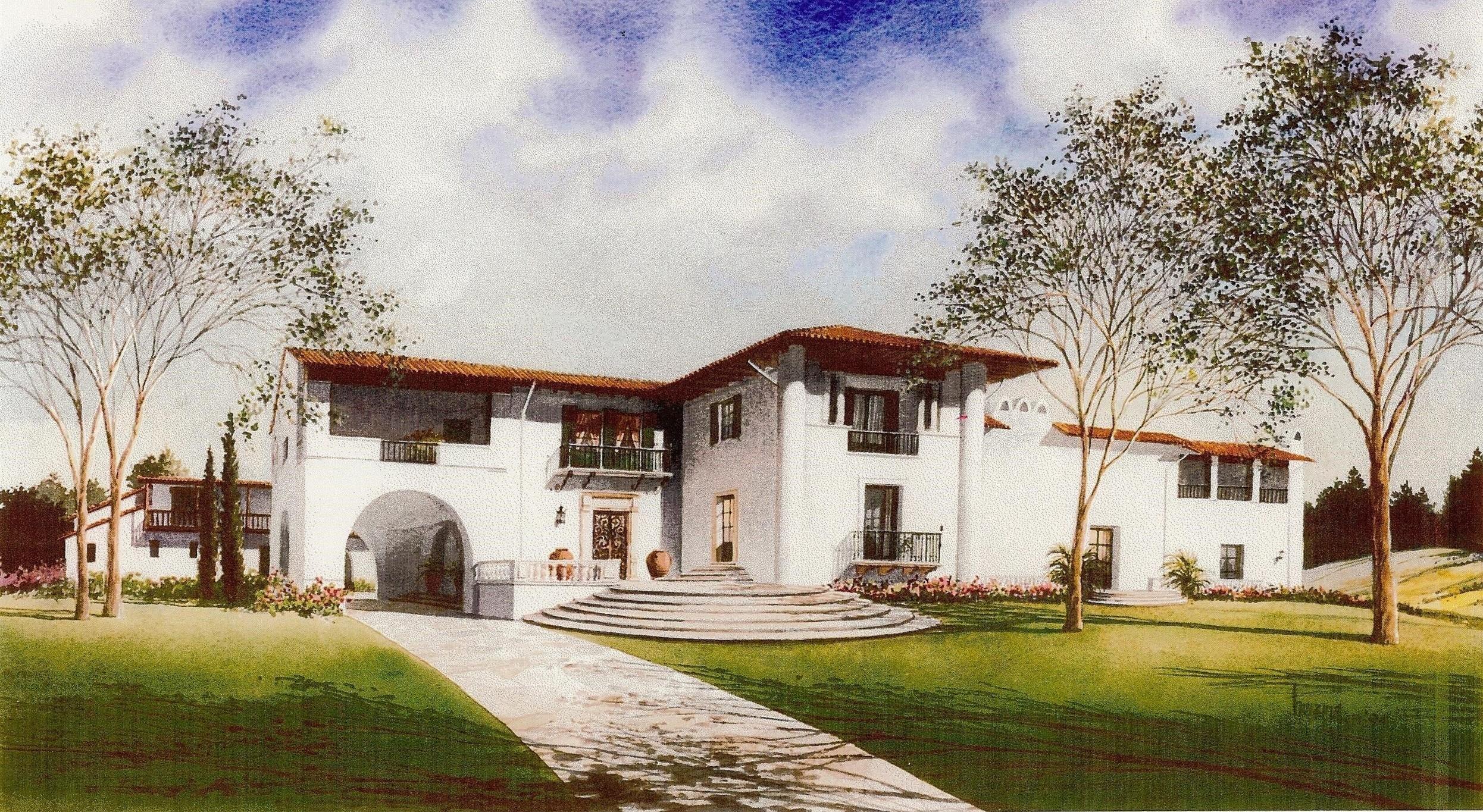
The above advertisement says that the Seymours’ lot “adjoins the aristocratic homes of Hon. Benj. F. Bledsoe, Harry H. Culver and numerous others.” Judge Bledsoe (mentioned earlier) resigned his federal judgeship to run (unsuccessfully) for Mayor of Los Angeles; H. C. Seymour presided over the campaign. The Seymour house, described as a “pretentious 2-story Morocco Spanish home … in the center of a large triangular lot which has a double frontage of approximately ½ acre,” was later home to crooner Vic Damone. It remains at 3114 Club Drive, at the corner of Shelby Drive.
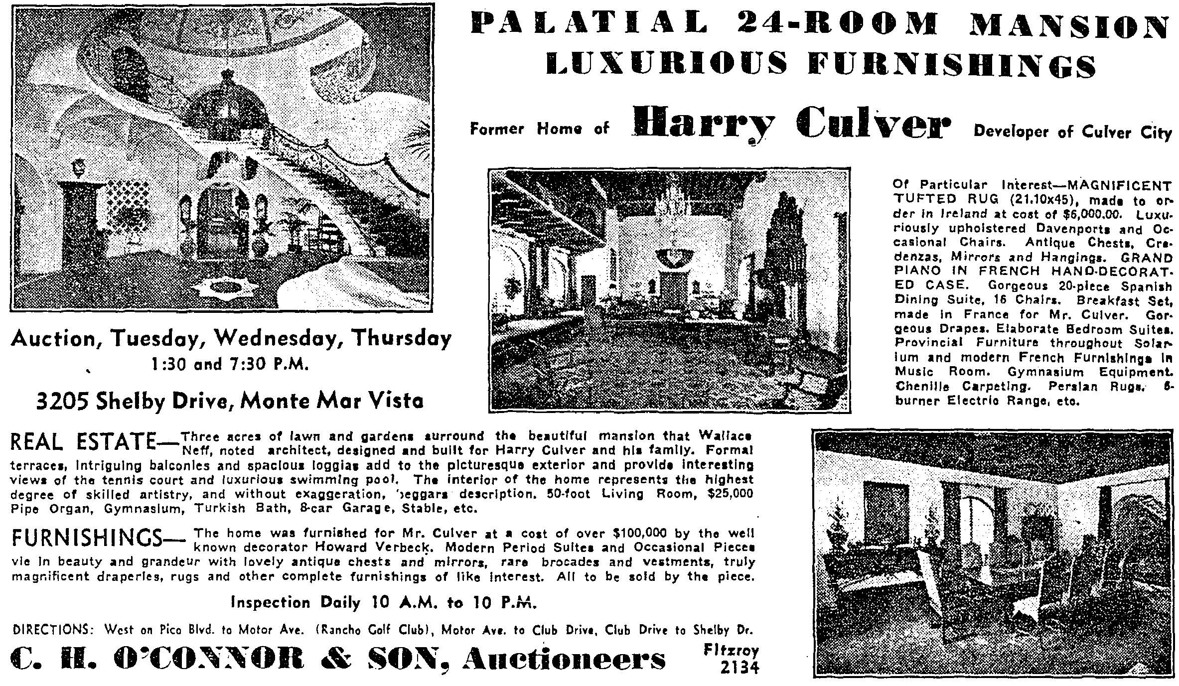
Harry Culver founded and developed Culver City. His Castle Heights home was the most magnificent in the Cheviot Hills neighborhood. On May 13,1934, the house, with its “three acres of lawn and gardens” at “3205 Shelby Drive, Monte Mar Vista” was advertised for auction. It was described as a “palatial 24-room mansion,” designed by “noted architect Wallace Neff,” with a $25,000 pipe organ, gymnasium, Turkish bath, 8-car garage and stables. It stood across the street from the California Country Club that Harry Culver had founded and up the hill from his Pacific Military Academy. His neighbor, Judge Bledsoe, was the Academy’s vice-president.
Other Castle Heights homes (or their contents) were auctioned during the Great Depression, both before and after Mr. Culver’s. On November 6, 1933, the “twelve-room Swiss Home” at “3260 Club Drive, Shelby Heights” would be offered at auction. In January 1937, the eight-room English home and furnishings of Mrs. Josephine Cherry were to be sold. And, in March 1937, the furnishings, paintings, Persian Rugs, and Kimball piano in the home of Lillian Kaye Bacon at 3244 Club Drive in “Shelby Heights” were advertised for auction. The auctioneer noted it was built and furnished by Harry Culver and formerly occupied by vaudevillian, comedian, actor, and Three Stooges creator Ted Healy. It may have been the house Culver lived in while his mansion on the California Country Club was built.
With the 1949 annexation of Los Angeles County’s Arnaz district, Castle Heights, as it is popularly understood, shifted eastward.