Where is was West Los Angeles?
Look closely at the 1888 official Los Angeles County Map (entered “according to Act of Congress”) to see that the city’s southwest corner was the original “West L.A.” (Until 1896, the city’s western edge was where present-day Hoover Street is located, along the map’s left edge.)

West L.A. was the converse of “East L.A.” – in the opposite corner of the map – which is now called Lincoln Heights. (East Los Angeles now denotes the unincorporated area in Los Angeles County east of the city, bordered by Boyle Heights to the west, Monterey Park to the east, and Montebello to the southeast.)
Forty years after the map, in 1928, the Los Angeles Times West Los Angeles denoted a far larger area many miles west:
… territory lying between Mulholland High Way on the north, National Boulevard and Venice Boulevard on the south and between Fairfax avenue and the Pacific Ocean.
(“It’s West Los Angeles Now, Vast Territory Adopts New Name After Survey, and Choice Gets Approval of Whole Area’s Leaders” (Los Angeles Times, Oct. 1, 1928).)
Samuel de la Torre Dórame (1947- ) explains (and illustrates) the name change in his unsurpassed history of Sawtelle, Sawtelle1897to1950:
The city of Sawtelle’s annexation to the city of Los Angeles in 1922 began the movement by the progressives (local merchants, social organizations, business leaders, local media newspaper, developers & investors and the majority of the additional newer towns people of Sawtelle) to change the name of the community of Sawtelle to the community of West Los Angeles. The goal of the Progressives, especially from the old Sawtelle community was to eliminate sub divisional names such as Sawtelle, Westwood, Brentwood, Holmby Hills and blend them into one community named West Los Angeles, with Sawtelle as the Western Los Angeles Metropolitan center, generally west of Beverly Hills and east of Santa Monica, to rival Hollywood, Beverly Hills and Santa Monica.
(Samuel de la Torre Dórame, Sawtelle1897to1950 [emphasis original].)
* * *
The names of the local institutions such as the Fire Department, Police Department, District Court, Sawtelle Women’s Club and many local businesses in Sawtelle were also renamed from Sawtelle to West Los Angeles. By the early 1930s most everyone jumped on the bandwagon to become West Los Angeles.
* * *
By the 1920s, the shanty town of Sawtelle was a stigma and hindrance to moving forward with the new vision for development of the entire West Los Angeles district. Sawtelle was developed years before the surrounding wealthy developments of Bel-Air, Brentwood, Westwood and Holmby Hills and was its own city in the early 1900s. Allowing the poorly pensioned Veterans to build their own community with their hammers and saws, was a noble Idea at first and the contrast between the shanty community of Sawtelle was not too obvious in the early 1900s. But into the 1920s and 1930s, with all the enormous and beautiful surrounding property developments of the rich and famous of Bel-Air, Holmby Hills, Brentwood and Westwood, the contrast between the ramshackle community of Sawtelle and those new wealthy developments was like night and day. The Progressive elite could not change the wood framed shacks owned by many low income property owners of Sawtelle, so, the course of action was to change the name of the community to West Los Angeles, I believe as an effort to hide and cover up the Sawtelle ramshackle community stigma.
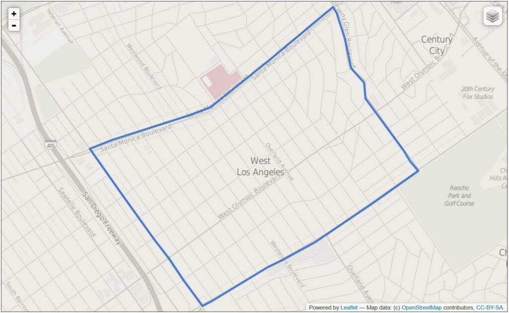
West Los Angeles meant something else in twenty-first century, when the Los Angeles Times’ “Mapping L.A.” Project would label the area east of the Sawtelle neighborhood “West Los Angeles” (the section of the City of Los Angeles between Santa Monica, Beverly Glen, Pico, and Sepulveda boulevards) even though it was nowhere near the City’s western edge.